Tuesday, August 23, 2011

Traveling the Oregon Coast: Great Fun on Highway 101

"A ship on the beach is a lighthouse to the sea." - Dutch proverb

After leaving the fry bread behind at the Nesika Illahee Pow-Wow in Siletz late Saturday afternoon, we raced the sunset as we headed south on Highway 101 from Newport. Golden hour beat us to the Heceta Head Lighthouse viewpoint (which is now unfortunately closed due to construction), but we were able to capture a few images of the lighthouse from a distance, even if the conditions were not ideal.

Heceta Head Lighthouse
There was, however, one photogenic seagull that seemed to be more than happy to have his picture taken, repeatedly, with the quickly fading sunset in the background.


We drove in the dark south past Coos Bay and parked the RV for the night. In the morning we headed for the nearest beach, Seven Devils State Park, a day use area, for a front row view of the ocean to accompany our breakfast. We arrived to find the place our own private playground, with not another soul in sight.

Merchant Beach

After what some might consider “begging” by the girls (okay, honestly, it didn’t take much on their part) we headed down to the sand to play. There are actually three beaches here: Agate (Yes, there is more than one along the Oregon Coast), Merchant, and Whisky. While the girls enjoyed themselves thoroughly, I think the look on my miniature pincher’s face says it all…

My dog Sarah
There is nothing better than a morning spent running and playing on the Oregon Coast!!

Alas, all good things must come to an end eventually, and there was still much to see between our current position and our scheduled destination for the night, my uncle’s house just outside Gold Beach. Once again we headed south on Highway 101.

A camping combination you don't see every day!
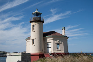
Coquille River Lighthouse sits within Bullards Beach State Park, just outside of Bandon, Oregon. Decommissioned in 1939 when a wildfire swept through the area. The first major restoration began in 1976 but the Fresnel lens is no longer in place and has since been replaced with a solar light.

The lighthouse missing the lens.
One could not have asked for Mother Nature to give a better backdrop for photographing the lighthouse that day. Bright blue sky and whispy blue clouds were like a dream come true. I took countless pictures from every angle. Below are a couple of my favorites.


From there, we headed back onto the highway to quite literally have a wild time! Stay tuned!!

Plan your own visit:


Thursday, August 18, 2011

Frybread - A Love Story (Nesika Illahee Pow-Wow)

In the Chinook language Nesika Illahee means “our land” or “our country. Every year during the second weekend of August, the Confederated Tribes of Siletz Indians celebrate their aptly named Nesika Illahee Pow-Wow on top of Government Hill in Siletz, Oregon.

After a former coworker, who also happens to be an enrolled member of the tribe invited me to attend 10 years ago, this has become an annual event for my family - morphing from a quick day trip my first year to now making an entire weekend of it. Not only does my husband’s family live in the area (which I found out about after I met him and this had already become a tradition for my oldest daughter and I) but I also have roots in the area through my father’s side of my family.


There are many reasons I enjoy this event so much – the beautiful wooded pow-wow grounds, the colorful costumes of the dancers, the rhythm of the drumming and the booths selling so many unique items from handmade creations to a rainbow of beads. However, there is one thing that stands out year after year – frybread!


Frybread is quite simply that – a piece of bread dough fried. Frybread entered the world during the US Government’s removal of the Navajo from their traditional lands in the mid 19th century. Imprisoned and starving at Fort Sumner, the only provisions supplied by the government to the Navajo were lard and white flour. From these poor rations, frybread was born.


I distinctly remember the first time I ever ate fry bread. It was October, 1998. I had just spent the morning exploring the ruins of Mesa Verde National Park, one of the most incredible places I have ever had the pleasure of visiting, when my friend and I happened upon what seemed like a mirage in the desert. A little gift shop and a small stand selling fry bread. Having never tried either before, I figured what the heck. I’ll give it a shot. I was immediately smitten with the warm, soft yet crispy, pillowy creation, covered in a light dusting of powdered sugar. I feasted on three pieces that day and have been hooked ever since.

Frybread can be served a whole multitude of ways. My favorite – Indian (or also known and Navajo or Native) taco style. It is quite simply exactly what it sounds like – a piece of frybread piled high with beans, seasoned ground beef, lettuce, cheese, fresh tomatoes and salsa, though the ingredients can vary depending on who is making it.


Sweet frybread is another option. My husband calls them elephant ears, which makes me cringe every time he says it. Elephant ears are thin and crispy. Frybread is thicker and more flavorful. It can be tossed with cinnamon sugar, served plain and then slathered in jam, or even strawberry shortcake style. The options are only limited by your imagination.


The Nesika Illahee Pow-Wow in Siletz is a great event. Put it on your calendar for next year and make plans to go down and make a weekend of it. Go to the parade through town on Saturday morning, stick around until Sunday for the tribal salmon feed, and in between watch the dance contests, do a little shopping and the vendor booths, and try some frybread for yourself!! 


Getting there:

The Siletz Nesika Illahee Pow-Wow is held annually the second weekend of August, which also normally coincides with the Perseid Meteor Shower (hint – hint).

Siletz is located approximately 13 miles northeast of Newport, Oregon along the Siletz River. While there is limited camping available on Government Hill, lodging options are plentiful a short drive away in Newport.

Related Links:


Tuesday, August 9, 2011

A Room With a View: Dee Wright Observatory

"The most beautiful view is the one I share with you." - Author Unknown

So, if you have read my blog much, you know my family rarely takes the most direct route anywhere. Therefore, we opted to detour and follow McKenzie Pass (Oregon Route 242) on our journey back towards the valley rather than the quick route home over Mount Hood. 

McKenzie Pass, which follows the path of an 1860s wagon route, features the highest concentration of snowcapped volcanic peaks (and associated glaciers) in the lower 48 states, making for an incredibly beautiful drive. Due to snow and ice, the road is only open seasonally, generally July to October. Depending on weather conditions (either early snowfall or late snowmelt in the high country) this timeframe may vary. So, if you are determined to go explore this scenic byway for yourself, make sure to check current conditions before heading out. 

The road was narrow and winding. While we were well under the maximum length limitation in the RV (the maximum vehicle length for this road is 30 feet and the RV was 25 feet long), I would not recommend this road for any large vehicle. There were times we were almost too wide to fit comfortably in our lane, and there was some white knuckle driving my husband had to endure. Was it worth it? Of course! Would we do it again in an RV? Probably not.

My husband enjoying the view along the highway

After a drive through the Deschutes National Forest, we were suddenly presented with a stark and barren landscape as the road starts traversing a 65 square mile lava flow. If it were not for a still snow capped Mount Washington in the distance, we might have thought that someone had suddenly dropped us into something right out of a National Geographic special about Kilauea and the island of Hawaii. The road appears to be literally chiseled into the lava bed. I can’t imagine how daunting early settlers in their wagons must have found this landscape, and as they reached this point on the wagon trail probably wondered what in the world they were thinking.


Mount Washington across the lava field

I have heard mention of Dee Wright Observatory in the past, but rarely paid much attention. Hearing the word "observatory," I had imagined a rather generic-looking structure with nothing especially unique or exciting about it. In fact, I had never even taken the time to Google it. I figured that if I happened to make it that way someday so be it, but it was by all means not worth a special trip. I was about to find out just how wrong it is for a person to make assumptions.


As you reach the summit of McKenzie Pass, there it stands, looking something like a cross between a medieval castle and a strange geologic formation as it rises from the volcanic rock. I sat there in my seat, half in wonder, half in surprise. I could not get my seatbelt off fast enough so I could get outside and see just what in the world this place really was.

Dee Wright Observatory via my iPhone and Instagram

Throughout this particular journey, the ongoing debate has been “What mountain peak is that?” as Central Oregon seems to be littered with the things. As official expedition navigator (i.e. holder of the map) I had a pretty good idea of what was what, but still, without someone actually pointing them out to me, it can sometimes be a little hard to discern (or it could be I am just a little bit map illiterate). This place was quite literally the answer to all of our questions.

Built in 1935 by the Civilian Conservation Core and named for the project foreman, Dee Wright Observatory sits in the shadows of North and Middle Sisters and has panoramic views of the Cascades, stretching as far north as Mount Hood on a clear day. On the roof of the structure is a bronze “mountain finder”, pointing out the peaks and other geologic features in the area. However, the inside of the building offers something a little more unique. 
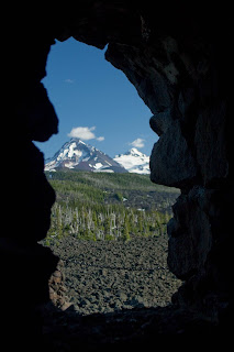
North and Middle Sisters through the Lava Tube

Small windows were marked by well worn plaques, mimicking lava tubes open to almost telescopic views of each mountain. Finally, we had a definitive answer to the journey long question: “Which mountain is that?” There was no room for debate or interpretation. When you gazed out the opening in the rock wall, you knew EXACTLY which mountain or butte you were viewing.

After enjoying dinner in the RV with what can only be described as a billion dollar view, we reluctantly headed down the other side of the pass, our sunlight rapidly fading. We traveled out of the desolate landscape of the lava field, into a rich and lush forest. I remarked to my husband, Jon, I wasn’t so much worried about a deer jumping out in front of us as a unicorn popping out from behind a tree. It was so beautiful it had to have been taken straight out of a fairy tale.

The sun finally disappeared behind the trees and we traveled home along the dark highway, certain we were missing some beautiful photo opportunities. We finally arrived home, an extra 70 miles or so added to the trip, a little road weary and looking forward to a night of rest in our own beds. 

Plan Your Own Visit:


Tuesday, August 2, 2011

Life is a Cascade Lakes Highway……

….and we drove it all afternoon long!!
 
After an excellent breakfast of homemade cinnamon rolls made by my aunt, it was time to hit the road and head back towards home….eventually. If you have been following this blog long, you know that we never take the shortest and most direct route home from any trip. Another round of everyone’s favorite game “Which mountain is that?” was also destined to begin.
 
Cascade Lakes Highway, near the beginning of our journey.
 
The Cascade Lakes Scenic Byway is a 66 mile loop around Mt. Bachelor to downtown Bend. We, however, did not start from the beginning, but near La Pine and the road that leads to Wickiup Junction. Most of the tour guides say to allow for at least 3 hours, which was about the amount of time we took. However, this did not allow for any time to hike, or do much more than jump out of the RV and snap a few pictures. It is definitely an area you can spend days in exploring, and I hope to get back and do this again in the future.
 
South Sister and Lava Lake
 
 Our first stop was Lava Lakes. There is a small resort here, with camping, a general store and boat rentals. While my husband, Jon, and our daughters chose to go explore the store (and found some great travel toys for the RV), I headed to the boat dock for the views of both Mount Bachelor and South Sister. While the weather may not have been ideal for capturing reflections of mountains in the water (a little too much wind), the views of both snow capped peaks were no less stunning. 
 
Mount Bachelor from the boat dock at Lava Lake
 
After, we headed back out on the highway, making brief stops at Hosmer Lake, Elk Lake, and Devil’s Lake. 
 
 
Devil's Lake
 
One stop of note was at an area just before we arrived at Sparks Lake. Mount Bachelor seemed so close you could touch it, and the wind was still enough here you could just catch a reflection of the peak in what water was visible through the lush, green vegetation. However, this also made for an ideal mosquito habitat. Even though it was the hottest part of the day, they swarmed me immediately as I exited the vehicle, attaching themselves to whatever skin was not protected by my clothing. Final bite total was about 20, but the picture was so worth it.
 
Mount Bachelor
 
Our final stop along the byway was Sparks Lake, where we also ate a late lunch. A beautiful lake encased in lava rock, with once again, spectacular mountain views. To the guy trying to take a swim, whom I “nicely” asked to get out of my shot of Broken Top, thank you for being so patient with me. Honestly, I am not always this obnoxious when I have the camera in my hands.
 
Broken Top and Sparks Lake
 
From there, we continued to Bend, towards another dilemma to ponder: Should we take the quick route home via Highways 97 and 26 over Mount Hood, Highways 20 and 22 to Salem and up I-5, or the really scenic route over McKenzie Pass? Which one do you think we chose???
 
Plan Your Own Trip: